To develop a scalable, evidence-based decision support system for Lesotho, our team followed a two-phase analytical approach: qualitative mapping, followed by quantitative spatial analysis.
Phase 1: Contextual Mapping of Lesotho
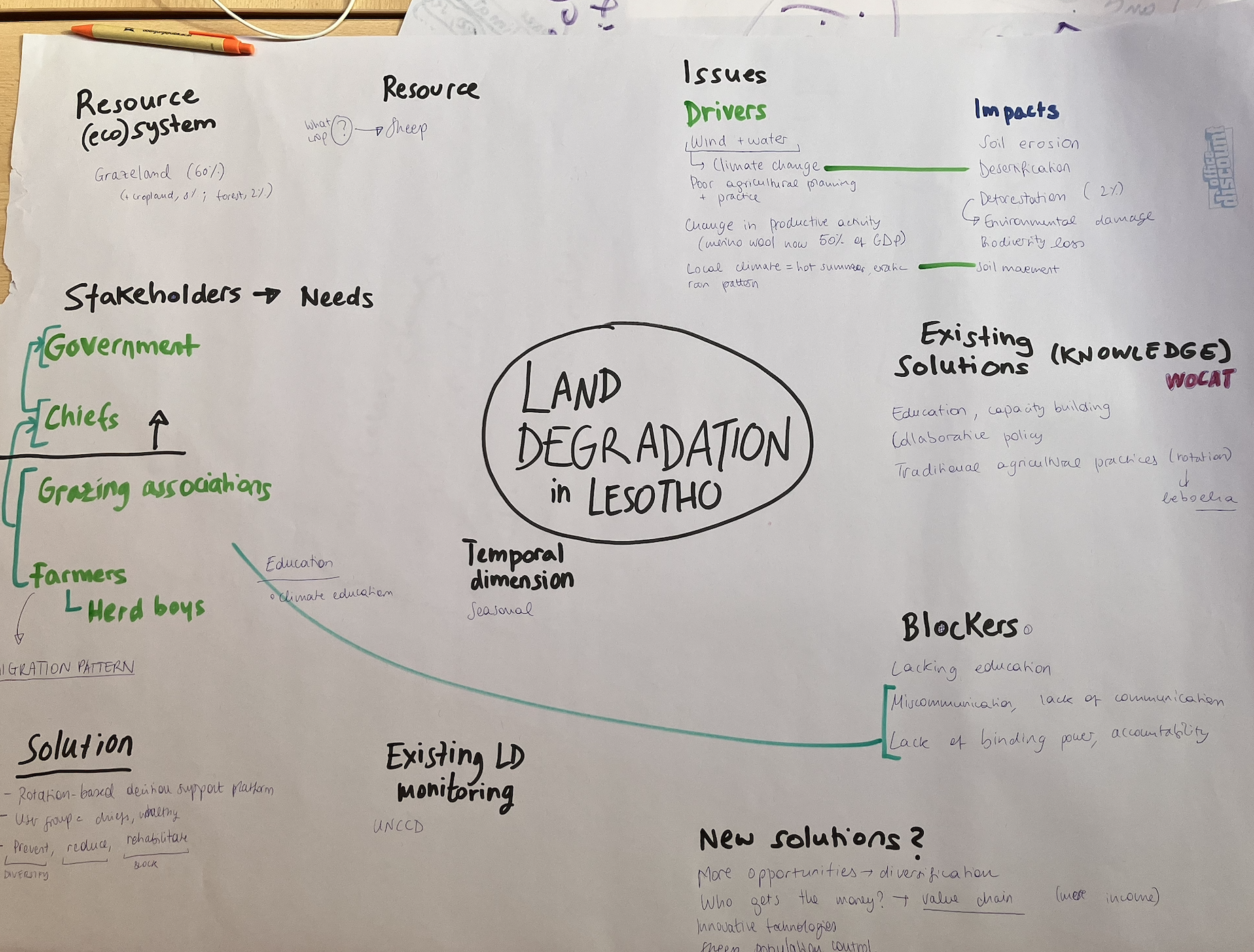
Before diving into the spatial data, we established a baseline understanding of the region by building a comprehensive systemic mind map of Lesotho. This helped us disentangle the complex relationships between the actors experiencing and causing degradation.
We categorized our findings into three core areas:
Stakeholders: Mapping local communities, livestock herders, smallholder farmers, and regional environmental authorities to understand who relies on the land and who governs it.
Drivers: Identifying the primary biophysical drivers (such as extreme topography, highly erodible soils, and shifting rainfall patterns amplified by climate change) alongside socio-economic drivers (such as overgrazing, unsustainable fuel-wood collection, and poor agricultural land management).
Impacts: Pinpointing the visible consequences of these drivers, specifically severe gully erosion ("donga" formation), declining soil fertility, loss of protective rangeland vegetation, and the subsequent threat to food security and downstream water quality.
Phase 2: Spatial Analysis and Hotspot Detection using Trends.Earth
To turn these qualitative insights into precise geographic locations, we conducted a spatial assessment using Trends.Earth within QGIS.
What is Trends.Earth?
Developed by Conservation International in partnership with NASA and Lund University, Trends.Earth is a free, open-source QGIS plugin backed by cloud computing. It allows users to process massive Earth observation satellite datasets to analyze land changes and track progress toward Sustainable Development Goal (SDG) Target 15.3 (Land Degradation Neutrality).
The Three Core Indicators
To calculate land degradation, the tool processes data across three legally recognized sub-indicators recommended by the United Nations Convention to Combat Desertification (UNCCD):
Land Productivity: Evaluates the biological productive capacity of the land by tracking long-term trends, state, and performance of biomass accumulation through time-series vegetation indices (like NDVI).
Land Cover: Identifies transitions between different land types (e.g., forest, grassland, cropland, artificial areas) over time to flag negative changes, such as woody encroachment or deforestation.
Soil Organic Carbon (SOC): Gauges overall soil health, nutrient cycling, and vulnerability to erosion by tracking changes in carbon stocks within the top 30 cm of the soil profile.
The "One Out, All Out" (1OAO) System
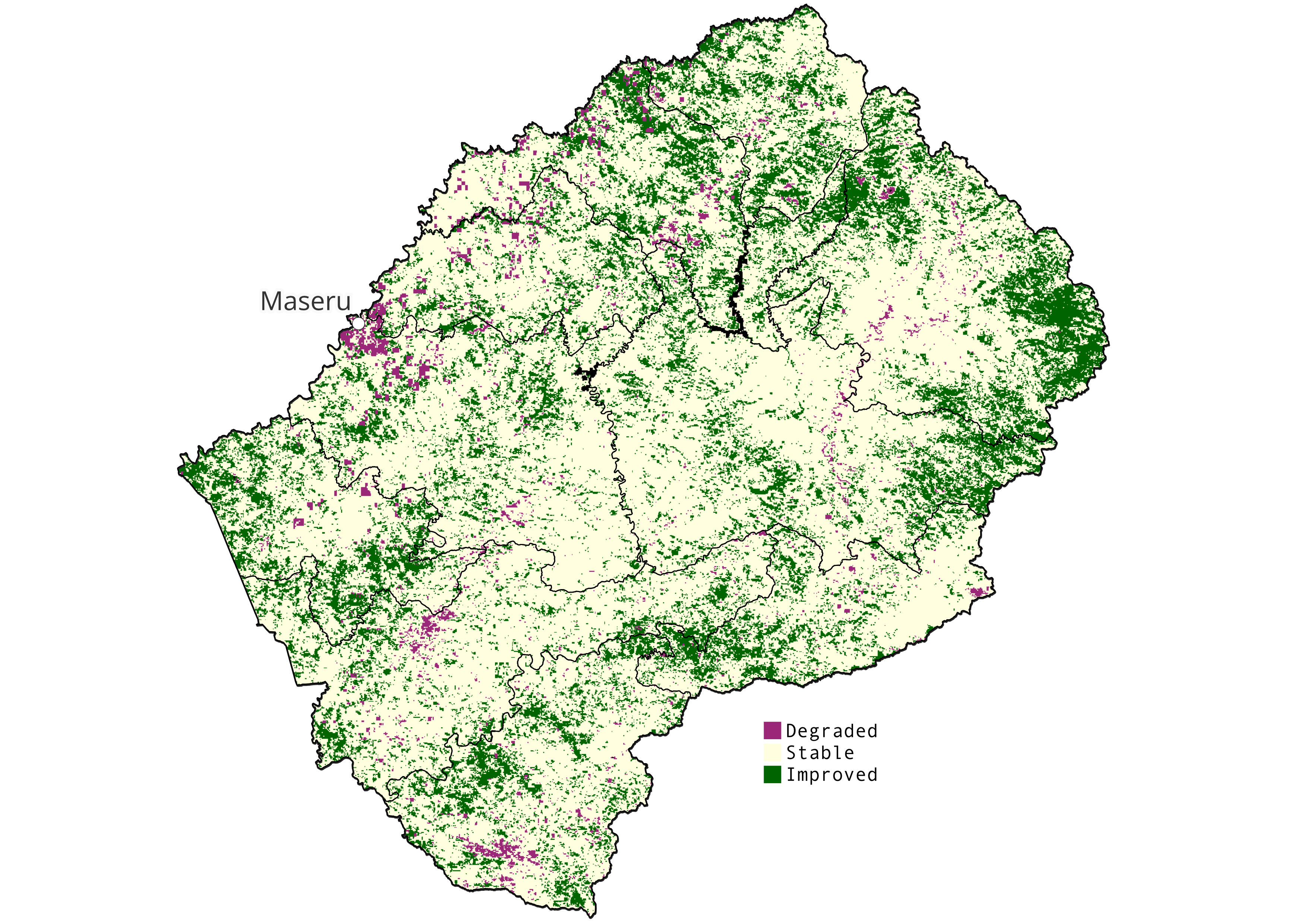
To combine these sub-indicators into a final, unified land degradation map, we applied the UN-recommended "One Out, All Out" (1OAO) principle. Under this strict precautionary framework, if any single one of the three sub-indicators exhibits a significant negative downward trend or degrading transition, the entire pixel or land unit is automatically classified as degraded. By running this multi-layered framework, we successfully isolated the primary biophysical hotspots of degradation across our study area. Below, you can see the map that resulted from this analysis, showing the areas that are most degraded, those that improved and those that remained stable in the reporting period 2010-2022.
Phase 3: Further analysis
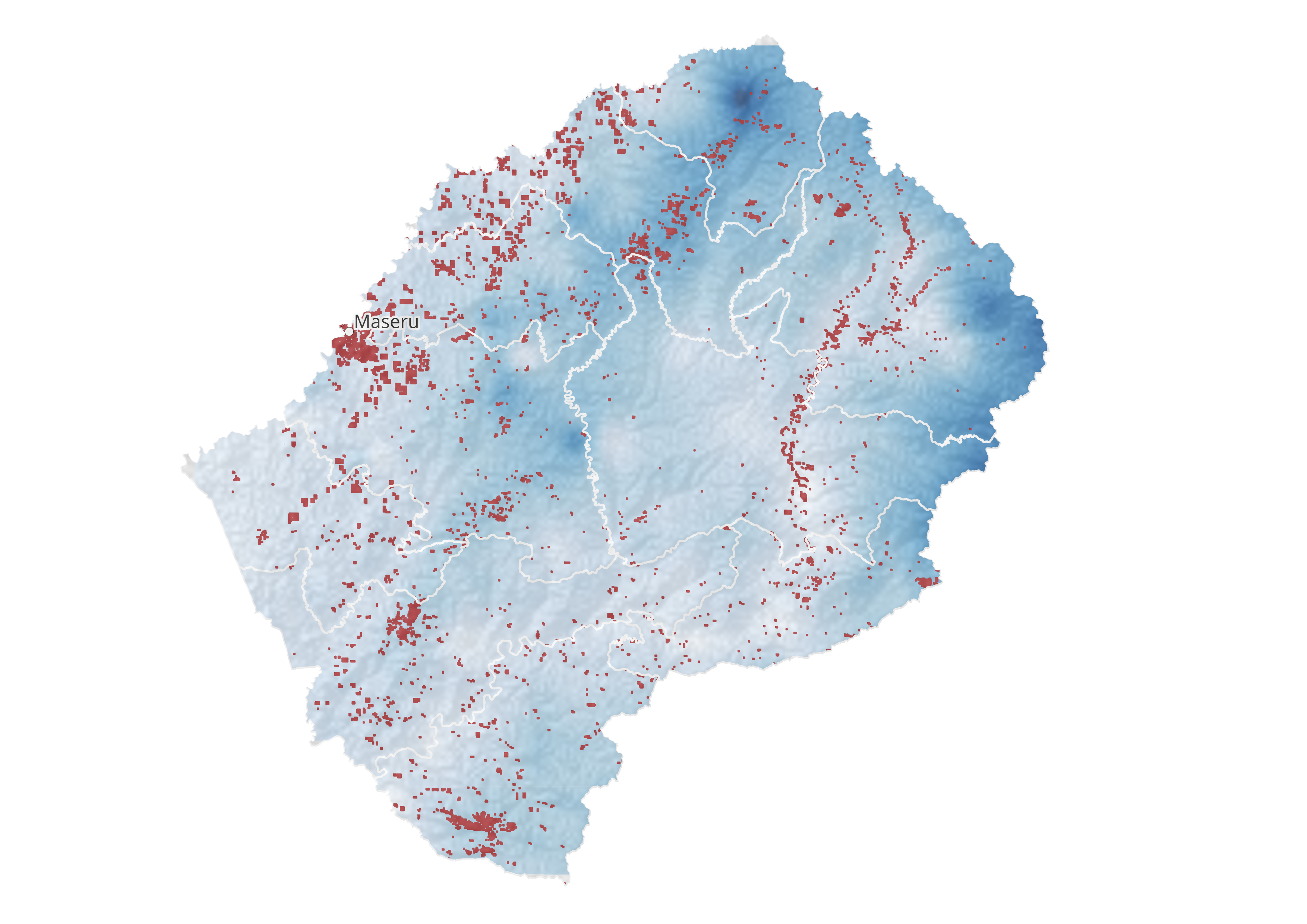
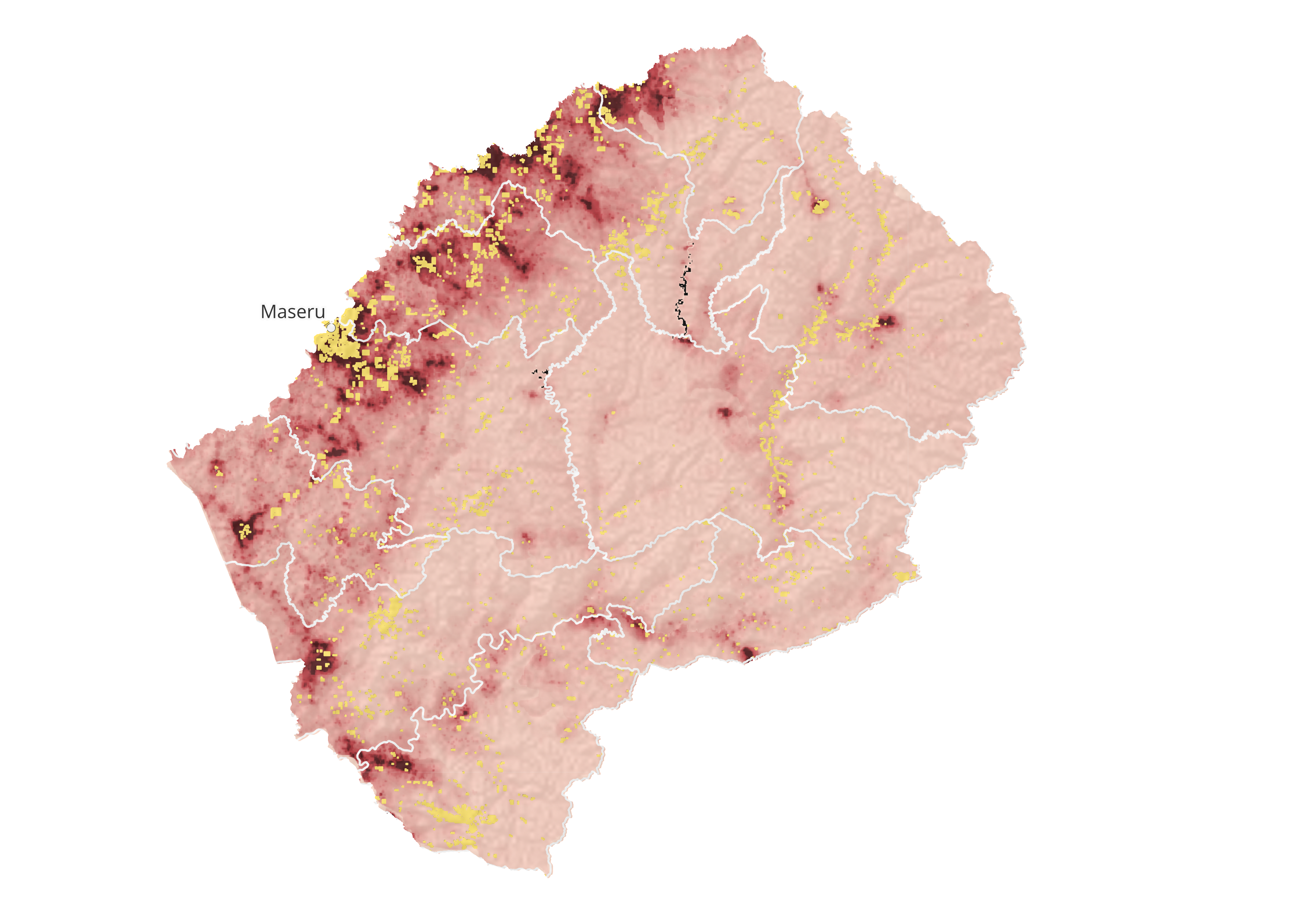
To take our analysis a step further, we decided to look at other variables into account. Having learnt that erratic rain patterns and drought can both influence land degradation, we decided to do an overlay analysis between the previously obtained hotspot areas and precipitation data (1981-2022). The map below shows, in a darker blue colour, the areas where yearly rainfall is more intense. If we understand rainfall as a proxy for drought, then we can see a trend of land degradation happening more in areas where the soil is drier.
This work is not finished
This project was completed in 48h as part of the Geo Youth Ideathon 2026 (more in the About section). This means that this work is far from complete. There are important climate variables missing, and an important way to further develop the project would be to also assess the specific vulnerability of the population, based on income, age or education levels. A huge issue in Lesotho is that livestock farming has become the main source of income for many people. Merino wool export makes up almost 50% of the country's GPD. Providing alternative livelihood opportunities is therefore a major step in ensuring that the population doesn't rely solely on grazing, and that the land has the opportunity to recover.With more time, it would be interesting to evaluate the topography of Lesotho, especially its slopes, to identify potential susceptibility for runoff and erosion. Finally, we concentrated on land degradation on grazeland, because this makes up almost 60% of the land cover. However, land degradation is also connected to deforestation and wetland degradation, which would also be important to look into for further analysis.
References
If you are interested in reading more about Lesotho, here are the sources we used.Government of Lesotho. (1999). Lesotho National Action Programme in Natural Resource Management, Combating Desertification and Mitigating the Effects of Drought. National Environment Secretariat (NES), Maseru, Lesotho.
Government of Lesotho. (1999). Lesotho National Report on the Implementation of the United Nations Convention to Combat Desertification (UNCCD): Report prepared for COP3.
Government of Lesotho. (2004). Third National Report: United Nations Convention to Combat Desertification (UNCCD). Ministry of Tourism, Environment and Culture, National Environment Secretariat.
Government of Lesotho. (2010). United Nations Convention to Combat Desertification Performance Review and Assessment of Implementation System: Fourth Reporting and Review Cycle – Report for Lesotho.
Government of Lesotho. (2012). United Nations Convention to Combat Desertification Performance Review and Assessment of Implementation System: Fourth UNCCD Reporting Cycle 2010–2011 – Report for Lesotho.
Government of Lesotho, Ministry of Forestry and Land Reclamation. (2015). Lesotho National Action Programme in Natural Resource Management, Combating Desertification and Mitigating the Effects of Drought.
Government of Lesotho. (2023). UNCCD Seventh Reporting Process: Report from Lesotho. United Nations Convention to Combat Desertification.
Likoti, M. L. (2019). Governing the Commons to Attain Land Degradation Neutrality in Lesotho. GRÓ Land Restoration Training Programme, Iceland. Available at: https://www.grocentre.is/static/gro/publication/729/document/likoti2019.pdf
Food and Agriculture Organization of the United Nations (FAO). (2022). Soil Erosion Key Driver of Wetland Degradation in Lesotho. FAO Regional Office for Africa. Available at: https://www.fao.org/africa/news-stories/news-detail/Soil-erosion-key-driver-of-wetland-degradation-in-Lesotho/en
World Vision International. (2024). Regreening Lesotho: Empowering Communities for Environmental Stewardship. Available at: https://www.wvi.org/stories/global-hunger-crisis/regreening-lesotho-empowering-communities-environmental-stewardship